Magmatic unrest in the Long Valley caldera, eastern California
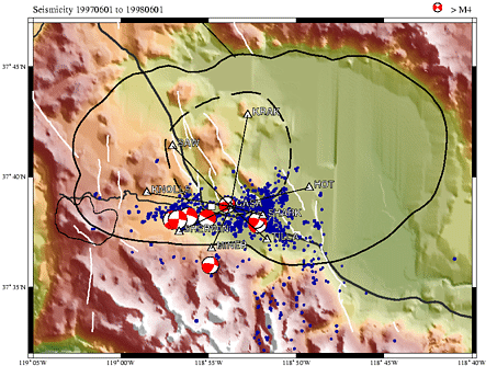
The Long Valley caldera in eastern California is a large, 32 by 17 km, silicic caldera that formed in the result of a catastrophic explosive eruption and collapse about 760,000 years ago. The volcanic activity has persisted in Long Valley up to the present, with the most recent eruptions occurring within the last several hundreds of years. The central part of the caldera is occupied by a resurgent dome that rises more than a hundred meters above the caldera floor. Figure on the right shows the caldera boundary (solid line) and the resurgent dome (dashed line), along with the shaded topography map, and seismicity that occurred within the caldera between the summers of 1997 and 1998. A number of geophysical indicators including high attenuation and velocity reduction of seismic waves, geothermal activity, and geodetically documented episodes of uplift suggest a presence of a contemporaneous magma body beneath the caldera floor. |
 |
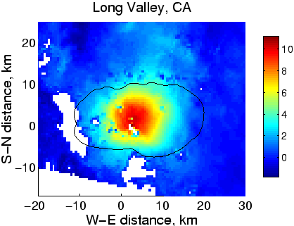 |
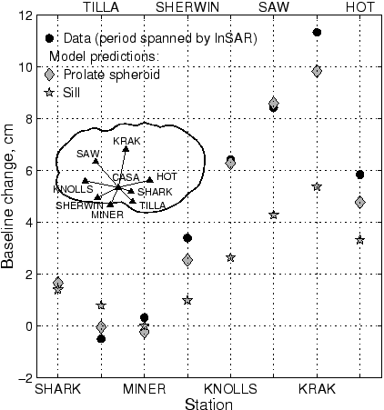
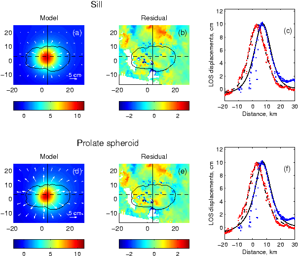
The most recent, 1997-1998, episode of inflation in Long Valley has been imaged in great detail by the ESA InSAR satellites. Next figure shows an unwrapped flattened interferogram from a descending orbit (track 485, frame 2840), with radar acquisition dates of June 6, 1996, and July 12, 1998. The InSAR data reveal a domal uplift of the Earth surface within the Long Valley caldera, with a maximum displacement of $\sim10$ cm in the satellite line of sight (LOS) direction. To get a further insight into the morphology of the inferred magma body beneath the Long Valley caldera, we invert the InSAR data for two ``end-member'' source geometries, a sill, and a prolate finite spheroid of arbitrary orientation. Because details of the source geometry cannot be resolved with only one component of the displacement field, we include in our analysis the two-color laser geodimeter data (data courtesy of J. Langbein, USGS). The two-color laser data provide accurate measurements of baseline changes within a trilateration network spanning the resurgent dome (see the top Figure). Results of our calculations are shown below. Both models are able to fit the InSAR data reasonably well. |
The source depths inferred from our modeling are 11-12 km for the sill, and 7-8 km for the vertically elongated magma chamber. The data from the USGS two-color geodimeter network provide important constraints on the morphology of the hypothesized magma body. As one can see in in the bottom Figure, the prolate spheroid model on average provides a better fit to the two-color laser data. The accurate determination, and monitoring of the deep-seated magma reservoir in Long Valley is important for forecasts of volcanic and seismic hazards in the area. For more details, please see this paper. |
 |
|